The Heat Dome’s Grip: Where Temperatures Are Soaring, Where Floods Are Striking — Full Report
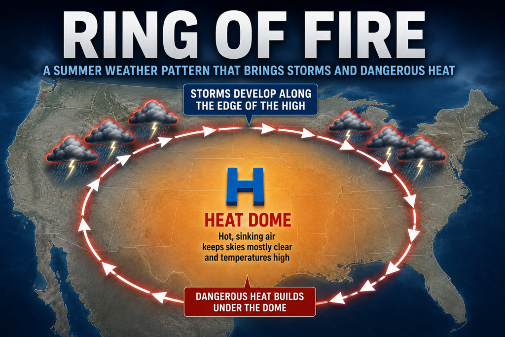
A dangerous heat dome parked over the central United States is now in its third straight week of gripping large parts of the country. On one side, temperature records are falling city after city; on the other, sudden flooding in several states has made the overall picture even more complicated. Here is a detailed, state-by-state report based on National Weather Service forecasts and expert assessments.
Where Temperatures Stand Right Now
Dallas-to-North Dakota corridor: Across this entire stretch, temperatures are holding above 100°F (38°C). Roughly 70 million people remain under heat advisories.
Western Nebraska: This is one of the worst-hit areas. Highs are forecast to reach 108°F (42°C) over the weekend, with extreme heat warnings in effect.
Montana and Wyoming: Even these normally mild mountain states are seeing temperatures push past 100°F this week — an unusual reading for the region.
Denver metro area: Forecasters have warned that decades-old temperature records could be broken here.
Colorado, Texas, Oklahoma, Arkansas: At least 10 heat records fell across these states over the past weekend alone. In Tulsa, Oklahoma, the temperature at Riverside Airport hit 105°F, far surpassing the previous record of 99°F set on the same date in 2001. Records also fell by one to six degrees in Muskogee and McAlester, Oklahoma, as well as Fayetteville and Fort Smith, Arkansas.
Desert Southwest to the Gulf Coast: This entire stretch is running 10 to 15 degrees above the seasonal average.
Texas and the Gulf Coast: Forecasters expect the most intense heat of the week to be centered here by Wednesday.
Areas getting a reprieve: The Mid-Atlantic, the Northeast and much of the Pacific Northwest are expected to avoid the worst of this round of extreme heat.
How Much Higher Could It Go
According to the National Weather Service, this stretch of extreme heat is expected to hold steady through the entire week. In already-hot areas, temperatures could climb further, and cities like Denver remain at risk of breaking long-standing records. This is far from an isolated event — earlier this month, New York City’s Central Park hit the 100-degree mark for the first time in nearly 14 years. Philadelphia reached 103°F, Washington, D.C. hit 102°F, and Boston touched 101°F. In other words, this heat pattern keeps returning throughout the summer, and more records are likely to fall in the days ahead.
What Weather Experts Are Saying
Bob Oravec, a meteorologist with the National Weather Service, said the weather pattern looks set to remain locked in place for the entire week. He added that some parts of the central US could see modest relief by next weekend, but cautioned that any cooling is likely to be temporary.
William Gallus, a professor of atmospheric science at Iowa State University, explains that a heat dome forms when a persistent area of high pressure traps hot air over a region. He notes that these systems can last anywhere from several days to several weeks and can stretch across multiple states.
Joseph Bauer, a meteorologist at AccuWeather, said conditions created by the heat dome have been conducive to approaching or breaking records in many areas, even though the daily records themselves haven’t necessarily been widespread.
On the climate front, Andy Pershing, chief programme officer at Climate Central, said the country is experiencing exactly what climate models from the 1990s predicted for this point in time — more frequent and more severe heat waves, larger temperature anomalies, greater humidity, and higher overnight temperatures.
Where Flooding Is Hitting
Alongside the heat, sudden and severe flooding has struck several states this month, pushing flash flood emergencies — the highest-level flood warning issued by the NWS — close to a monthly record.
Texas Hill Country: Between July 15 and 17, this region was hit by a 1-in-1,000-year flood event, with some areas receiving nearly a year’s worth of rain in just a few days. This marked the second consecutive year the region has been struck by flooding of this magnitude.
Uvalde, Texas: A single night of 7 inches of rain triggered a flash flood emergency and forced more than 40 water rescues.
Laredo and Webb County, Texas: The Rio Grande was forecast to crest near 21 feet — roughly four times its typical level of under 5 feet — prompting a moderate flood warning for the area.
Missouri: A week before the Texas floods, Missouri saw its own 1-in-1,000-year rainfall event, with campers rescued from cabin rooftops and trees.
West Virginia: Record flooding was recorded here as well, particularly around Huntington and surrounding areas.
Utah: Flooding struck areas within wildfire burn scars, where scorched land is especially prone to runoff.
New York City and neighboring states: Repeated flash flood warnings have been issued as heavy thunderstorms move through. The city’s aging stormwater system can handle only up to 1.75 inches of rain per hour, a threshold that recent storms have increasingly exceeded.
Atlanta and North Georgia: Flash flood warnings were recently issued simultaneously across Cobb, DeKalb, Douglas, Fulton, Gwinnett, Barrow, Floyd, Carroll, Haralson and Paulding counties, with one to two inches of rain recorded.
Nashville, Lexington (Kentucky) and Charleston (West Virginia): These cities remained under flood watches as well.
Climate scientists note that for every 1°F rise in temperature, the atmosphere can hold about 4% more water vapor. Since the US has warmed by nearly 3 degrees on average since 1970, there is now significantly more moisture available to fuel heavy downpours — which helps explain why extreme heat and destructive flooding are increasingly striking at the same time.
When Will Relief Arrive
Per meteorologist Bob Oravec, parts of the central US could see a modest drop in temperatures by next weekend. However, he was clear that this relief is likely to be short-lived, and the heat pattern could return. The Mid-Atlantic, Northeast and Pacific Northwest are currently avoiding the worst of the heat, but forecasters caution that this could change at any time.
State-by-State Forecast Snapshot
| State/Region | Current Conditions | Outlook |
|---|---|---|
| Texas (Dallas, Hill Country) | Above 100°F; recent catastrophic flooding | Peak heat expected Wednesday; recovery from floods ongoing |
| North Dakota | Above 100°F | Heat expected to persist through the week |
| Nebraska (western) | Up to 108°F; extreme heat warnings | Peaks over the weekend, possible modest relief after |
| Colorado (Denver) | Near record levels | Long-standing records at risk of falling |
| Montana/Wyoming | Unusually above 100°F | Heat expected to continue through the week |
| Oklahoma (Tulsa) | 105°F; record broken | Heat likely to persist |
| Arkansas | Record temperatures set | Little relief expected in the near term |
| West Virginia | Record flooding | Continued rain and flood risk |
| New York/New Jersey | Repeated flash flood warnings | Ongoing risk of thunderstorms and flooding |
| Georgia (Atlanta) | Heavy rain, flash flood warnings | Unsettled weather expected to continue |
| Mid-Atlantic/Northeast/Pacific Northwest | Relatively moderate | Spared the worst heat for now, but conditions could shift |
Bottom Line
The United States is currently facing a two-front weather crisis — a heat dome that is breaking temperature records across dozens of cities, paired with a surge in sudden, destructive flooding fueled by unusually high atmospheric moisture. Experts say the two phenomena are closely linked: a warming climate allows the atmosphere to hold more moisture, which then manifests either as extreme heat or as flash flooding. The National Weather Service is urging residents to stay alert and continue monitoring local advisories closely.